CG Fry West Southill
Home
About Us
Land West of Southill
Find out about
  • Ecology and Open Space
  • Movement & Access
  • Flood Risk & Drainage
  • Sustainability
  • Social Infrastructure
  • What happens next
Submit Comments
CG Fry West Southill
Home
About Us
Land West of Southill
Find out about
  • Ecology and Open Space
  • Movement & Access
  • Flood Risk & Drainage
  • Sustainability
  • Social Infrastructure
  • What happens next
Submit Comments
More
  • Home
  • About Us
  • Land West of Southill
  • Find out about
    • Ecology and Open Space
    • Movement & Access
    • Flood Risk & Drainage
    • Sustainability
    • Social Infrastructure
    • What happens next
  • Submit Comments
  • Home
  • About Us
  • Land West of Southill
  • Find out about
    • Ecology and Open Space
    • Movement & Access
    • Flood Risk & Drainage
    • Sustainability
    • Social Infrastructure
    • What happens next
  • Submit Comments

Movement and Access

Site Access

Two new access junctions will serve the proposed development, in the form of simple priority T-Junctions. One will be situated along Radipole Lane (the eastern site access), and the second along the unnamed road which serves as access for the Police Station and the Wessex Golf Centre (the western site access). An additional pedestrian/cycle only is access proposed at Grafton Avenue, providing connectivity to Southill and its local facilities

Active Travel Links

There is an opportunity for connection to a shared foot/cycleway to be provided along Radipole Lane, within the vicinity of the eastern site access and Wessex Roundabout as set out in the Council’s Active Travel Infrastructure Plan. At Wessex Roundabout accessibility is available to the town’s wider network of existing walking and cycling routes. Chafey’s Avenue and Field Barn Drive are also classified by the Council as advisory routes for on-street cycling. A new bus stop is proposed on Radipole Lane within the vicinity of the eastern site access. The internal layout of the site will allow for bus movements should this be required in the future. 

Local Facilities

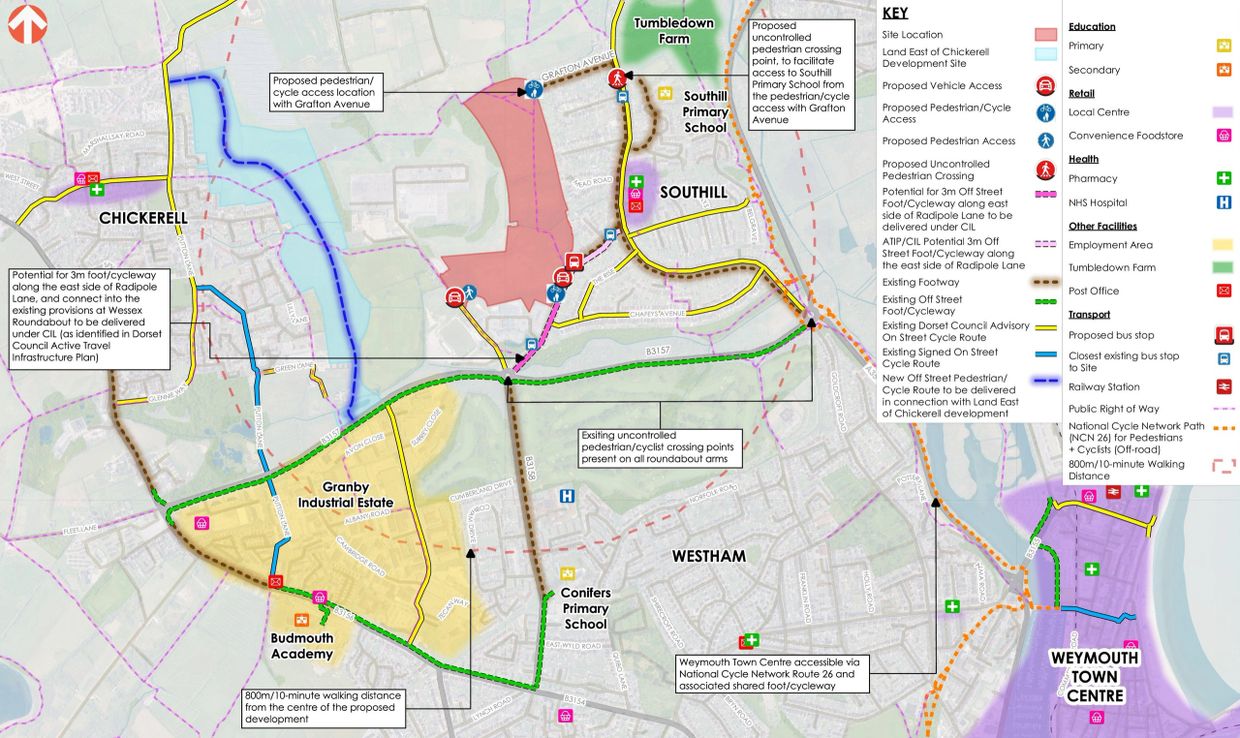
  •  Southill Primary School – 11-minute walk from the proposed pedestrian/cycle connection with Grafton Avenue
  • Budmouth Academy – 8-minute cycle from the eastern site access
  • Central convenience shop/post office – 5-minute walk from the eastern site access
  • Granby Industrial Estate – 4-minute cycle / 17-minute walk from the eastern site access
  • Weymouth Town Centre – 9-minute cycle from the eastern site access, via National Cycle Network Route 26  

Bus Connectivity

The closest bus stop can be reached within a 10-minute walk from the site, known as ‘Mayfield Close’. The 3 bus service provides an hourly service during the day, with an additional service in the evening peak hour, to Weymouth town centre via Southill, Westham and Westhaven Hospital. Additional bus services can be reached from Weymouth Town Centre, as well as Weymouth Railway Station. 

Traffic Impact

The proposed development is expected to generate approximately three movements every minute in both the AM and PM peak hours. A Travel Plan will be implemented at the development to promote the use of active and sustainable modes of travel by residents living at the site. 

Back to Land West of Southill

Copyright © 2026 CG Fry West Southill - All Rights Reserved.


Powered by

This website uses cookies.

We use cookies to analyze website traffic and optimize your website experience. By accepting our use of cookies, your data will be aggregated with all other user data.

DeclineAccept